Background
The Global Ultraviolet Imager (GUVI) is one of four instruments that constitute the TIMED spacecraft, the first mission of the NASA Solar Connections program. The TIMED spacecraft is being built by Johns Hopkins University Applied Physics Laboratory and GUVI is a joint collaboration between JHU/APL and the Aerospace Corporation. TIMED will be used to study the energetics and dynamics of the Mesosphere and lower Thermosphere between an altitude of approximately 60 to 180 kilometers.
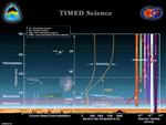
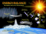
It is designed to observe the glow of the Earth's upper atmosphere in ultraviolet light so we can better understand the properties of the upper atmosphere. GUVI will be used to determine energy inputs from the sun into the Mesosphere and Lower-Thermosphere Ionosphere (MLTI) region of the upper atmosphere where ultraviolet light ionizes the atoms and molecules. This area of Earth's atmosphere is home to the aurora and electrical currents that heat the upper atmosphere during magnetic storms. It's where radio waves are reflected back to Earth making long-distance radio communication possible.
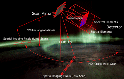
GUVI is a far-ultraviolet (115 to 180 nm), scanning imaging spectrograph that provides horizon-to-horizon images in five selectable wavelength intervals, or "colors." These colors include HI 121.6 nm, OI 130.4 nm, OI 135.6 nm, and N2 Lyman-Birge-Hopfield bands 140 to 150 nm and 165 to 180 nm.
It will globally measure the composition and temperature profiles of the MLTI region, as well as its auroral energy inputs. GUVI will look at sources of far-ultraviolet light originating in the Earth's upper atmosphere, such as the aurora, and will count individual particles of light, or photons, emitted by the atmosphere. GUVI is the first instrument sensitive enough to look, in detail, at composition changes in the upper atmosphere.
GUVI will provide information on the ionosphere and thermosphere by monitoring three general regions: the daytime low to mid-latitude thermosphere, the nighttime low- to mid-latitude ionosphere and the high-latitude auroral zone. With the development of sophisticated remote sensing instruments capable of obtaining simultaneous monochromatic images at a number of wavelengths, and automated data processing techniques, it has become possible to routinely produce maps of the characteristics of the upper atmosphere.
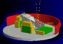
GUVI is based on heritage from the Special Sensor Ultraviolet Spectrographic Imager (SSUSI), an instrument previously built for Defense Meteorological Satellite Program Block 5d-3 satellites, which will fly on the DMSP Block 5D3 satellites F-16 through F-20. The instrument consists of a scan mirror feeding a parabolic telescope and Rowland circle spectrograph, with a wedge-and-strip detector at the focal plane.
GUVI products include maps of the auroral oval, the characteristic energy and flux of the electrons which excite it, F-region ionospheric electron density profiles, and dayside neutral composition information. These products will be useful to DoD and civilian users and can support many basic research activities as well. With fifteen years of continuous coverage of the composition and dynamics of the upper atmosphere, we will have the unprecedented opportunity to study the effects of global climate change on the upper atmosphere.