Understanding GUVI Data Products
The GUVI Data Processing Payload Operations Center will routinely create scientific data products that are available for distribution via the web. In order for the data to be of use to scientists, industry and the public, rapid, efficient, and accurate operational algorithms must be developed into environmental parameters. Data from the GUVI instrument is processed on the ground to generate data products at the different levels.
| GUVI Data Levels | |
|---|---|
| Data Level | Brief Description |
| 1A | time and position tagged data |
| 1B | calibrated and geolocated |
| 1C | binned in GUVI coordinates |
| 2B | routine key parameters |
| 3 | multiple orbits |
For Imaging data, the Level 1A is a "virtual" data product file in the sense that the data is not directly written to a data file. It consists of raw sensor data at full resolution. The Spectrograph Level 1A is routinely produced as data product file. The Level 1B data product contains uncompressed instrument data, using a simple constrained maximum error compression algorithm that achieves modest compression factors, and has been calibrated to convert to units of radiance within the specified "color" of the GUVI data (Rayleighs/color).
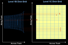
The Level 1C data products contain data directly measured by the sensors, such as photometer counts, uncertainties, light intensities and pointing information derived from the GUVI raw sensor data and the TIMED Satellite ephemeris data. The data are gridded into a GUVI based coordinate system consisting of the along orbit position of the sensor and the angle of the scan from the nadir position. This gridding eliminates overlap from scan to scan due to the large instantaneous field-of-view of GUVI (about 12 degrees) and involves coaddition to place the values on a uniform instrument shared grid. The data is gridded at different resolutions appropriate for day, night, or aurora analyses. Note that each gridding extends over the entire data product, and it is up to the user to determine the boundaries appropriate for each analysis type.
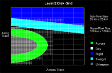
The Level 2B data products contain environmental parameters which are derived from the sensor data by scientific algorithms specific to day, night, and auroral regions. The data is averaged into 100 x 100 km2 resolution to form "super pixels" on the day and night and 25 x 25 km2 for the auroral products. The "super pixels" are then processed by the algorithms to yield geophysical parameters which are calculated from the radiance of the different colors.
| GUVI Data Products | |
|---|---|
| Aurora | Day |
| Boundary Specification | Solar EUV flux index, Qenv |
| Effective* energy flux, Q | O/N2 ration on disk |
| Effective* average energy, <E> | Temperature profile |
| Height of peak ionization rate | Neutral density profiles [NDPs] O, N2, O2 on limb |
| Column ionization rate | |
| Total vertical column density | |