Fact Sheet
Mission Summary
GUVI supports the Thermosphere, Ionosphere, Mesosphere, Energetics, and Dynamics (TIMED) mission science objectives to determine the:
- Spatial and temporal variations of constituent number densities and temperature in the thermosphere
- Relative importance of auroral inputs, Joule heating, and solar EUV for the thermal structure of the lower thermosphere
GUVI is a far ultraviolet (115 to 180 nm) scanning spectrograph imager which provides horizon-to-horizon images in five selectable wavelength intervals or "colors." These colors (HI 121.6 nm, OI 130.4 nm, OI 135.6 nm, and N2 Lyman-Birge-Hopfield bands 140 to 150 nm and 165 to 180 nm) are chosen in order to produce the GUVI key parameters.
Instrument Characteristics
GUVI uses a scan mirror to sweep its 11.78 degree field-of-view through an arc of up to 140 degrees in the plane perpendicular to the orbital plane. This instantaneous field-of-view is mapped via an f/3 Rowland circle spectrograph into 14 spatial and 160 spectral "pixels." The detector is a micro-channel, plate-intensified, wedge-and-strip anode sealed tube that provides a two-dimensional readout. A detector processor bins the data into the five selected colors.
Orbital Coverage
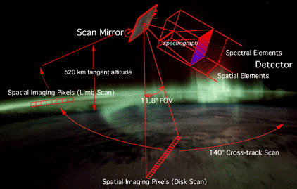
GUVI scans from horizon-to-horizon and up onto the limb that is away from the Sun. For a nominal 625-km orbital altitude, GUVI will scan up to a 520-km tangent altitude providing a nearly complete coverage of the globe on successive orbits. A typical orbit includes day, night, and auroral observations. The swath width is about 3000 km. Successive orbits provide overlapping coverage at the poles and nearly contiguous coverage at the equator.
Data Processing
The GUVI Payload Operations Center will host the data-processing hardware and software, as well as the primary GUVI data archive. The GUVI data catalog, browse data products, and data request facility will be available to users. The goal is to process GUVI data and provide a provisional certification for release within 48 hours of receipt at the GUVI POC. Routine data processing will take the data to at least Level 2.
|
|
||||||||||||||||||||||||||||
| GUVI Key Parameter Accuracies - Dayside Science | |||||
|---|---|---|---|---|---|
| FEATURES | SPATIAL SCALE | ALTITUDE | PRECISION* | INFERRED | ACCURACY |
| Limb | |||||
| OI (135.6) | 130-300 km | ±3% | N2,O2,O | ±15% | |
| LBH (1) | 250 km Horizontal | ±7% | Solar EUV | ±10-15% | |
| LBH (2) | ±10% | Temp | ±8% | ||
| HI (121.6) | 100 x 100 km2 | 110-300 km | ±1% | H | ±10% |
| Disk | |||||
| OI (135.6) | 100 x 100 km2 | 130-300 km | ±3% | [O]/[N2] | ±5% |
| LBH (1) | ±5% | N2,O2,O | ±20% | ||
| HI (121.6) | 100 x 100 km2 | 110-300 km | ±1% | H | ±10% |